The Named Roads That Built America Before the Interstate Existed
The Map Before the Map
Most Americans think of road trips as an interstate invention — something born from the 1950s, tail fins, and the Federal Aid Highway Act of 1956. But long before the numbered green signs went up, drivers were already criss-crossing the country on roads with names. Romantic names. Names like the Lincoln Highway, the Dixie Highway, the Old Spanish Trail, and the National Old Trails Road.
These were the auto trails — loosely organized, often volunteer-mapped routes that civic boosters, automobile clubs, and local businessmen stitched together in the early 1900s to connect one town to the next. They weren't engineered with military precision. They weren't always paved. But they were alive in a way that most modern highways simply aren't.
And a surprising number of them still exist — hiding in plain sight along two-lane state routes, through courthouse squares, and past diners that haven't changed their pie recipe since 1947.
How the Auto Trails Actually Worked
Here's the thing nobody tells you about early American road travel: there was no federal authority deciding where the roads went. Instead, private organizations — sometimes called trail associations — lobbied local governments, painted colored bands on telephone poles as route markers, and published their own maps and guidebooks to lure drivers onto their specific corridor.
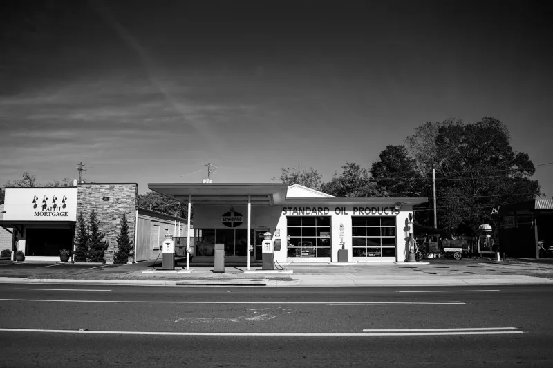
The Lincoln Highway, established in 1913, was arguably the most famous. It ran roughly 3,400 miles from Times Square in New York City to Lincoln Park in San Francisco, passing through small-town Pennsylvania, the flat belly of Iowa, the salt flats of Utah, and the Sierra Nevada foothills. It was the first road in America explicitly promoted as a coast-to-coast automobile route — and it created an entire ecosystem of gas stations, tourist cabins, roadside stands, and local diners that didn't exist before cars showed up.
The Dixie Highway was another one. Conceived around 1915 as a way to connect Midwestern cities to Florida's tourist trade, it eventually split into two parallel branches — one running through the Appalachian interior, the other hugging the Georgia coast — before merging again in Miami. Towns that landed on the Dixie Highway boomed. Towns that didn't often faded.
That's the part that hits differently when you actually drive these routes today.
What Happened to the Towns Along the Way
When the Interstate Highway System arrived in the late 1950s and '60s, it didn't just build new roads — it redirected economic gravity. Traffic that once flowed through the center of small towns was rerouted around them. Motels, restaurants, and filling stations followed the new highways. The old auto trail towns were left with their main streets, their architecture, and not much else.
In some cases, that's tragic. But in others, it's accidentally preserved something remarkable.
Take a stretch of the old Lincoln Highway through central Pennsylvania — bypassed by I-80 decades ago. Towns like Schellsburg and Everett still have their original brick commercial blocks, their vintage motor lodges, their roadside diners with hand-lettered signs. The road itself narrows and curves in ways that remind you it was built for 30-mile-per-hour travel, not 75. You pass farms, creek crossings, and the kind of hardware stores that sell things you'd have to order online anywhere else.
Or drive a segment of the old Dixie Highway through northern Georgia, where the route threads through small cities that grew up entirely around the tourist trade it generated — towns with grand old hotels and filling station buildings that have since become antique shops and barbecue joints.
None of this shows up in your GPS as a recommended route. That's precisely the point.
How to Actually Drive One
The good news is that the Lincoln Highway Association (yes, it still exists) maintains detailed maps and a website that lets you trace the original route state by state. The Lincoln Highway Heritage Corridor in Pennsylvania is one of the most organized, with interpretive signs, historic markers, and a community of local historians who genuinely love talking about the road's past.
For the Dixie Highway, the research is a bit more scattered, but enthusiasts have mapped large portions of both branches using old state highway records. A drive from Chattanooga, Tennessee south through Georgia on the eastern branch is particularly rewarding — you'll pass through towns that still bear the architectural fingerprints of early 20th-century tourism.
The National Old Trails Road — a route that roughly paralleled what would later become Route 66 through Missouri, Kansas, and the Southwest — is another worth investigating, especially if you want to understand why Route 66 became culturally iconic. The Old Trails Road was doing the same thing a generation earlier, and almost nobody talks about it.
Why This Matters Beyond Nostalgia
There's a reason these routes feel different from anything you'd find on a standard road trip itinerary. The interstate was designed for efficiency — to move people through places as quickly as possible. The auto trails were designed to move people into places. Every named route was built around the idea that the towns along the way were the destination, not the obstacle.
That philosophy created a roadside culture — roadside architecture, really — that's genuinely unlike anything built after 1960. Googie diners, vernacular motor courts, hand-painted barn advertisements, and small-town main streets that were never demolished because traffic never abandoned them dramatically enough to justify redevelopment.
Driving these routes isn't a history lesson. It's more like finding a frequency your regular radio doesn't pick up. The country is still broadcasting on it. Most people just stopped tuning in.
If you want a road trip that feels like an actual discovery rather than a highlight reel, skip the interstate for a day. Find the nearest stretch of a named auto trail. Take the curves slowly. Stop when something looks interesting.
The whole point of these roads was always to stop.