The Lost Art of Reading Rivers Like a Book — Before Maps, Americans Spoke Water
The Lost Art of Reading Rivers Like a Book — Before Maps, Americans Spoke Water
Stand on any riverbank today and you'll likely see water flowing past. But to your great-great-grandfather, that same view would have been a complex story written in liquid — one that could predict next week's flood, reveal the safest place to cross, or warn of ice dams forming miles upstream.
Before the National Weather Service started issuing flood warnings in 1871, Americans developed an intricate language for reading water. River pilots on the Mississippi, homesteaders crossing the Great Plains, and Native American communities across the continent all shared variations of the same skill: the ability to predict what a river would do next by reading the landscape around it.
The Grammar of Moving Water
The most reliable river readers weren't necessarily the ones who spent the most time on the water. They were the ones who understood that rivers don't just flow — they communicate through everything they touch.
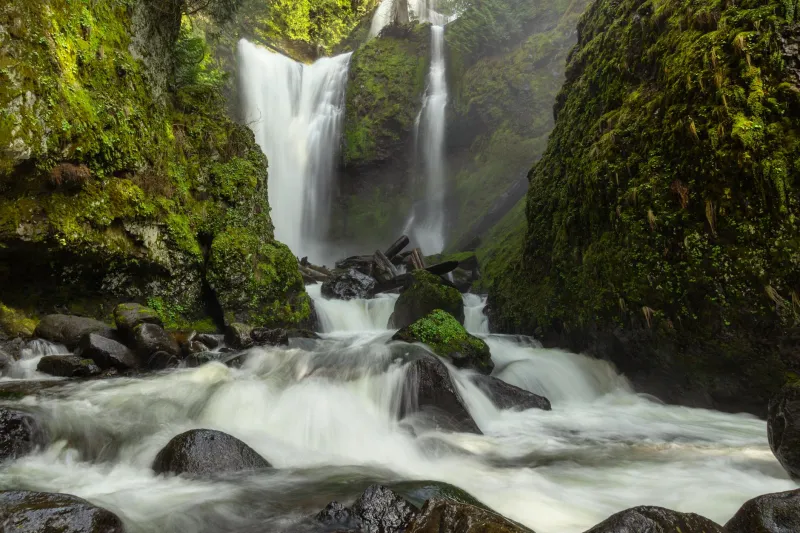
Take cottonwood trees, for instance. These fast-growing giants don't just happen to cluster near rivers; they position themselves at specific elevations that reveal a waterway's personality. Old-timers knew that cottonwoods growing in perfectly straight lines marked the high-water point of regular spring floods. But cottonwoods growing in scattered, seemingly random patterns? That meant flash floods — unpredictable surges that could turn a gentle creek into a wall of water in minutes.
Moss told its own story. River readers learned that moss growing only on the north side of trees near water indicated consistent, predictable flow patterns. But when moss appeared on all sides of riverside trees, it signaled a waterway prone to dramatic level changes — the kind that could strand a wagon train or wash out a bridge without warning.
The Sandbar Telegraph
Perhaps no feature revealed more about a river's intentions than its sandbars. To untrained eyes, these temporary islands look random, but experienced river readers could decode them like a topographic map.
Sandbars that formed in gentle, crescent shapes indicated stable flow patterns. These rivers were predictable, safe for regular crossings, and unlikely to change course dramatically. But jagged, angular sandbars pointed to turbulent waters underneath — rivers that could shift their entire channel overnight during heavy rains.
Mississippi River pilots developed the most sophisticated sandbar reading system in America. They knew that sandbars appearing upstream of a bend meant the river was cutting a new channel. Sandbars forming downstream of a bend indicated the old channel was filling in. This knowledge wasn't just academic — it determined whether a steamboat could safely navigate a route or would run aground miles from help.
Reading the Ripples
Surface patterns revealed what lay beneath. Smooth, glassy water usually meant deep channels, but experienced readers knew to watch for subtle exceptions. A perfectly smooth patch surrounded by gentle ripples often indicated a submerged log or boulder — invisible to the eye but deadly to anyone trying to cross.
V-shaped ripple patterns pointing upstream revealed rocks just below the surface. V-shaped patterns pointing downstream indicated deeper water flowing around an underwater obstacle. The difference between these two patterns could mean the difference between a safe crossing and a dangerous one.
Colorado River guides developed their own vocabulary for reading water. "Haystacks" — standing waves that looked like piles of hay — indicated deep, fast-moving channels. "Holes" — areas where water seemed to disappear — marked spots where the current dove deep, creating powerful suction that could trap boats and swimmers.
The Revival Nobody Talks About
While most Americans lost this knowledge when we moved to cities and started trusting technology over observation, a small community of modern river readers has been quietly reviving the practice.
Canoe instructors in Minnesota teach students to read the "river's resume" — the story written in bent trees, undercut banks, and debris lines that reveal how high water rises during spring melts. Fly fishing guides in Montana still use traditional methods to predict where trout will feed based on how current patterns interact with fallen logs and gravel bars.
Some park rangers have begun incorporating river reading into their training, recognizing that satellite data and computer models can't always predict flash floods in narrow canyons or ice jams in northern streams.
What Your Next Hike Can Teach You
You don't need to become a professional river guide to start reading water. Next time you're near a stream or river, try these basic observations that our ancestors took for granted:
Look for the "bathtub ring" — a faint line on rocks and trees that shows regular high-water marks. This reveals the difference between normal flow and flood stage.
Notice which direction riverside trees lean. Trees leaning downstream have been pushed by regular high water. Trees leaning upstream indicate areas where water regularly backs up, creating dangerous hydraulics.
Watch for color changes in the water. Muddy water entering clear water shows you where tributaries join the main stream — and often indicates recent rainfall upstream.
The Language We Lost
In an age of GPS and weather apps, reading rivers might seem like an obsolete skill. But every spring, when unexpected floods catch communities off guard despite all our technology, it becomes clear that we've lost something valuable — the ability to have a conversation with the landscape itself.
The next time you cross a bridge or walk beside moving water, remember that you're looking at one of nature's most detailed storytellers. You just need to remember how to read what it's trying to tell you.